Hydrogeology
An aquifer is a water-bearing geologic formation that can yield usable amounts of water. An aquifer may be a layer of gravel or sand, a layer of sandstone or limestone, or even a body of massive rock such as granite, which has sizeable cracks and fractures. An aquifer may be anywhere from a few feet to several hundred feet thick. Aquifer materials may be classified as consolidated or unconsolidated rock.
The quantity of water a rock can contain depends on the rock’s porosity, the total amount of spaces among the grains or in cracks that can fill with water. Sand or gravel contain relatively large interconnected spaces between particles and will generally yield sizeable quantities of water. On the other hand, clay may contain a considerable amount of water and yet the pore spaces are so small that water cannot move freely between them. Therefore, clay layers tend to impede water movement and are not productive aquifers. Crystalline rock, such as granite, contains very little pore space and has very low permeability. However, nearly all bedrock is broken by cracks, fractures or faults, which may enlarge over time. These cracks tend to hold water and, when intercepted by a well, will often yield usable quantities of water.
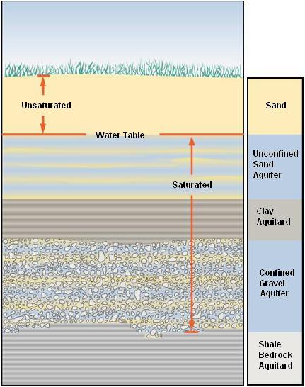
In many areas there may be multiple aquifers stacked on top of one another. (Fig.1) These distinct layers of water-bearing material are often separated by impermeable layers of clay or rock, which prevent water from moving readily from one aquifer to another. These impermeable layers are generally referred to as confining layers or confining beds. An aquifer, which does not have a confining layer above it, is said to be unconfined or at atmospheric pressure. The upper surface of the saturated zone in such an aquifer is referred to as the water table. In water table aquifers, water may move readily from surface sources such as streams and rivers to groundwater and vice-versa. The water level in these aquifers fluctuates readily with changes in precipitation patterns. An aquifer lying beneath a confining layer is commonly called a confined aquifer. As the water flows beneath the confining layer, the impermeable layer above it essentially traps it. Consequently, the water in the aquifer may be confined under pressure. When a well is drilled into such an aquifer, this artesian pressure will cause the water level in the well to rise above the point where the well intercepted the aquifer. The level to which water will rise into tightly cased wells from aquifers is called the potentiometric surface. If a well is drilled in a low-lying area where the surface of the ground is lower than the potentiometric surface, water will flow from the well under its own pressure, i.e. a flowing artesian well. Since artesian aquifers are overlain by confining layers, recharge to the aquifer can only occur in places where the confining layer leaks, is absent, or where the aquifer is exposed at the ground surface. These areas are known as recharge areas.
Fig.1: Subsurface view of various aquifers. Image courtesy OMAFRA
Groundwater moves by the force of gravity from recharge areas to discharge areas. Groundwater movement is generally very slow, typically only a few feet per year. However, in more permeable zones, such as solution channels in limestone or fractures in crystalline rock, it may move as fast as several feet per day. Groundwater, particularly from the water table aquifers, typically discharges into streams, lakes and wetlands. Where the water table intercepts the ground surface, water can discharge, forming springs or seeps.
Several factors cause groundwater levels to fluctuate. These levels naturally rise and fall because of seasonal patterns of groundwater recharge and storage. Groundwater levels tend to be highest in the spring and lowest in late summer. In late spring, summer and early autumn, evaporation and transpiration by plants use up most of the water that would otherwise recharge the aquifer. At the same time, the aquifer is discharging water into streams, springs and wells. A seasonal decline in groundwater levels results. In the late fall, winter and early spring, most plants are dormant and evaporation rates are low. Consequently, precipitation events during this time of year tend to saturate the soil, stream levels rise, and groundwater recharge occurs, resulting in water level increases.
Longer-term changes in groundwater levels may occur because of climate and pumping changes. Less groundwater recharge will occur during dry years than in wet years. Several years of below normal rainfall will typically result in a gradual decline in water levels. Groundwater levels can also be affected by pumping from wells. When water is pumped from a well, the water level in the well is drawn down, forming a cone-shaped depression on the water surface. This cone of depression is maintained as long as the well is pumping but is usually localized and does not affect other wells in the area. However, when several high-capacity wells are pumping in the same vicinity, the cones of depression may overlap and cause a general lowering of the water level in an area. When this happens during a time of dry weather, the water level may drop to the point that shallower wells in the area go dry and the water level drops below the pump inlet in others.