The Nottawasaga Valley Conservation Authority

Our Wetlands

Wetlands in the Nottawasaga Watershed

The Nottawasaga Watershed contains more than 4,000 individual wetlands that are greater than 0.1 hectares. To many, wetlands are great spots for fishing, hunting, paddling, hiking, bird-watching, and are valuable outdoor “classrooms” for people of all ages.

In Ontario and many places around the world, wetlands are “graded” by significance. In Ontario, the Ministry of Natural Resources and Forestry uses the Ontario Wetland Evaluation System, which is a provincially-approved protocol that reviews the ecological, hydrological, social and “special feature” components of a wetland complex. A provincially significant wetland is identified by the province as the most valuable.

One of these wetlands are the internationally significant Minesing Wetlands and 33 provincially significant wetlands as well as 34 important but non-provincially significant wetlands. There are approximately 80 wetlands and wetland complexes that are mapped in the watershed but unevaluated. Several of the unevaluated wetlands would likely provincially significant if they were evaluated. Regardless of evaluation status, all wetlands contribute to a healthy watershed and provide valuable ecosystem services including flood control and providing clean drinking water.

So what are wetlands, and why are they so amazing?

Wetlands are also very important for flood control, water filtering, groundwater recharge and discharge and wildlife habitat. When there is a lot of rain or snowmelt, wetlands absorb and slow floodwaters, which helps to alleviate property damage and can even save lives. In the face of climate change, these wetlands are ever more important as we experience more extreme storm events.

Wetlands are areas that have very wet soils and vegetation that are adapted to seasonally/permanently high-water table and/or seasonal flooding. The amount of water in the wetland depends on how much water is in the groundwater, river or stream around it.

Drier SWD SW of marsh (all E of trail)

In the Nottawasaga Watershed, wetlands fed by rivers and streams or sometimes local drainage features (i.e. vernal pools) and are wettest during and after the spring snowmelt and are typically drier during summer and early fall. They may refill later in the late fall depending on the amount of rainfall. Water levels in groundwater-fed wetlands are relatively stable.

There are four general types of wetlands: bog, fen, marsh, and swamp. In the Nottawasaga Watershed, swamps and marshes are the most common, while fens are relatively rare and no bogs have been found.

Fen

Fen

​​

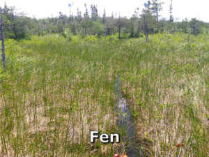
Fens are wetlands fed by stable groundwater inputs. This type of wetland produces peat and a specific plant community dominated by shrubs, grasses, sedges and herbs with occasional trees such as cedar and tamarack.

Marsh

Marsh

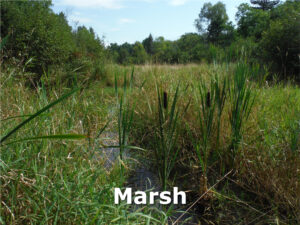
Marshes are wetlands with vegetation that is exposed to high water tables and/or standing water on a near-permanent basis. Too wet to support swamp forest cover, they often have recognizable plants like cattails, bulrushes and lily pads and have almost no shrub or tree coverage. Abandoned fields in low-lying areas often regenerate into marshes and if left alone may continue to transition into a swamp. In the Nottawasaga Watershed, marshes are often connected to large rivers and lake shorelines.

Swamp

Swamp


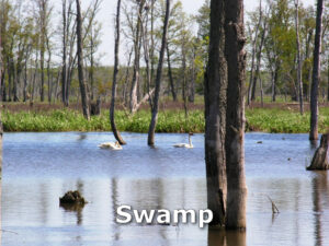
Swamps are forests that are adapted to seasonal flooding. Some swamps, especially the ones with conifer trees, are fed by groundwater. Water levels in floodplain swamps, including parts of Minesing Wetlands, can rise and fall by more than 2 m over the course of the year

Although these forests are adapted to wet conditions, if the wetland becomes too wet or too dry, the trees will not be able to tolerate these changes. For instance, if too wet, it may convert to a marsh or thicket swamp. Pressures like land use and climate change can change wetland water regimes at a local level (Georgian College Wetland) or watershed level (Minesing Wetlands).

In the Minesing Wetlands, the floodplain forests have significantly died back over the decades due to changes in land use across the watershed. These changes include clearing of natural areas of agricultural intensification and urban development.

Scroll to Top